
Picture 1 of 3


ENDED
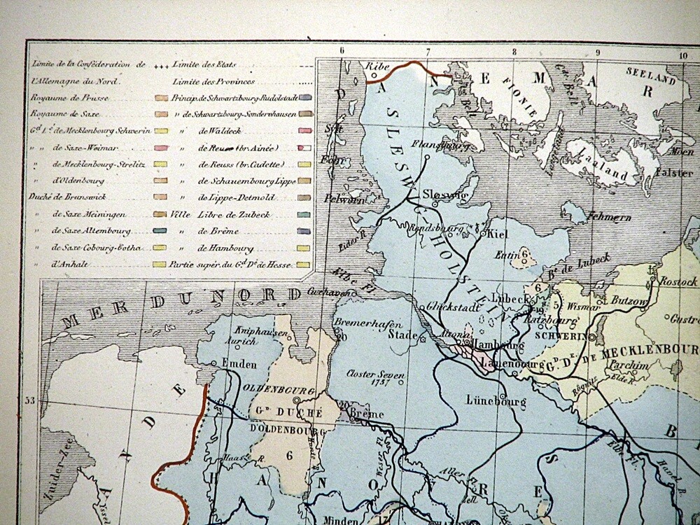
1866 Map Northern Germany Confederation Hand Colored Lithograph 11.5 x 9.5"
Condition:
“See photos for condition description. Pictures are of the actual item(s) you will receive.”
Price:
US $31.71
ApproximatelyPHP 1,860.81
Postage:
Located in: Belton, Missouri, United States
Delivery:
Estimated between Fri, 7 Jun and Mon, 10 Jun to 43230
Returns:
Coverage:
Read item description or contact seller for details. See all detailsSee all details on coverage
(Not eligible for eBay purchase protection programmes)
Seller information
- 100% positive feedback
Registered as a Business Seller
Seller assumes all responsibility for this listing.
eBay item number:375400766071
Item specifics
- Seller Notes
- “See photos for condition description. Pictures are of the actual item(s) you will receive.”
- County
- Various
- Cartographer/Publisher
- Hachette
- Printing Technique
- Lithography
- Original/Reproduction
- Antique Original
- Format
- Atlas Map
- Type
- Political Map
- Year
- 1866
- City
- Various
- Date Range
- 1800-1899
- Country/Region
- Germany
- State
- Germany
Item description from the seller
Seller assumes all responsibility for this listing.
eBay item number:375400766071
Postage and handling
Item location:
Belton, Missouri, United States
Post to:
Americas, Asia, Australia, Europe
Excludes:
Barbados, French Guiana, French Polynesia, Germany, Guadeloupe, Libya, Martinique, New Caledonia, Reunion, Russian Federation, Ukraine, Venezuela
| Postage and handling | To | Service | Delivery*See Delivery notes |
|---|---|---|---|
| US $6.50 (approx PHP 381.43) | United States | Standard Postage (USPS Ground Advantage®) | Estimated between Fri, 7 Jun and Mon, 10 Jun to 43230 |
| US $9.50 (approx PHP 557.48) | United States | Expedited Postage (USPS Priority Mail®) | Estimated between Fri, 7 Jun and Mon, 10 Jun to 43230 |
| Handling time |
|---|
| Will usually ship within 1 business day of receiving cleared payment. |
| Taxes |
|---|
| Seller charges sales tax in |
Sales Tax for an item #375400766071
Sales Tax for an item #375400766071
Seller collects sales tax for items shipped to the following states:
| State | Sales Tax Rate |
|---|---|
| Missouri (MO)* | 9.1% |
Return policy
| After receiving the item, contact seller within | Refund will be given as |
|---|---|
| 30 days | Money Back |
The buyer is responsible for return postage costs.
