Picture 1 of 6


Picture 1 of 6


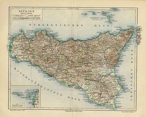
Antique Map of Sicily in Italy-The Agedian Islands-Sizili

US $49.50
ApproximatelyPHP 2,752.60
or Best Offer
Condition:
“Good, given age. Original middle fold, as issued. General age-related toning and/or occasional minor ”... Read moreabout condition
Postage:
US $14.95 (approx PHP 831.34) Standard Shipping from outside US.
Located in: Zeeland, Netherlands
Delivery:
Estimated between Mon, 30 Sep and Fri, 18 Oct to 43230
Returns:
30 days return. Buyer pays for return shipping.
Coverage:
Read item description or contact seller for details. See all detailsSee all details on coverage
(Not eligible for eBay purchase protection programmes)
Shop with confidence
Seller assumes all responsibility for this listing.
eBay item number:354183914154
Item specifics
- Seller Notes
- Type
- Topographical Map
- Height (Centimeters)
- 18.0
- Width (Centimeters)
- 23.5
- Color
- Multi-Color
- Country/Region
- Italy
- City
- Sicily
- County
- Not applicable
- Format
- Atlas Map
- Cartographer/Publisher
- Joseph Meyer
- Printing Technique
- Lithography
- Original/Reproduction
- Antique Original
- Date Range
- 1600-1699
- Year
- 1613
- Subject
- Maps
- Publisher
- Joseph Meyer
- Medium
- Lithograph
- Framing
- Unframed
- Signed
- Plate signed
- Size
- Small
- Orientation
- Landscape
- Height (Inches)
- 7.1
- Width (Inches)
- 9.3
- UPC
- Does Not apply
- EAN
- 8718613172619
Item description from the seller
Business seller information
Value Added Tax Number:
- NL 820763196B01
