Picture 1 of 3


Gallery
Picture 1 of 3


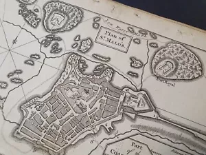
Antique Map Plan of Fort St Saint Malo Brittany France 1758

GBP 75.00
ApproximatelyPHP 5,673.33
or Best Offer
Condition:
Oops! Looks like we're having trouble connecting to our server.
Refresh your browser window to try again.
Shipping:
GBP 26.99 (approx PHP 2,041.64) International Priority Shipping to United States via eBay's Global Shipping Program.
Located in: Leyburn, United Kingdom
Import charges:
Free amount confirmed at checkout
Delivery:
Estimated between Mon, 23 Jun and Wed, 2 Jul to 94104
Includes international tracking
Returns:
No returns accepted.
Coverage:
Read item description or contact seller for details. See all detailsSee all details on coverage
(Not eligible for eBay purchase protection programmes)
Seller assumes all responsibility for this listing.
eBay item number:326316933041
Item specifics
- Date Range
- 1700-1799
- Antique
- Yes
- Type
- Topographical Map
- Format
- Sheet Map
- Year
- 1758
- Era
- 1700s
- Cartographer/Publisher
- Unknown
- Original/Reproduction
- Antique Original
- City
- St Malo
- Country/Region
- France
Item description from the seller

Seller feedback (3,127)
- eBay automated feedback- Feedback left by buyer.Past monthOrder completed successfully—tracked and on time
- i***y (3490)- Feedback left by buyer.Past monthVerified purchaseA OK CHEERS
- eBay automated feedback- Feedback left by buyer.Past monthOrder completed successfully—tracked and on time