Picture 1 of 11


Gallery
Picture 1 of 11


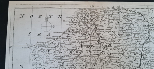
Original antique (c. 1775) map - Netherlands (incl. modern Belgium & Luxembourg)

GBP 15.95
ApproximatelyPHP 1,206.53
Condition:
Oops! Looks like we're having trouble connecting to our server.
Refresh your browser window to try again.
Shipping:
GBP 17.27 (approx PHP 1,306.38) International Priority Shipping to United States via eBay's Global Shipping Program.
Located in: Romford, United Kingdom
Import charges:
Free amount confirmed at checkout
Delivery:
Estimated between Thu, 19 Jun and Mon, 30 Jun to 94104
Includes international tracking
Returns:
30 days return. Buyer pays for return shipping. If you use an eBay shipping label, it will be deducted from your refund amount.
Coverage:
Read item description or contact seller for details. See all detailsSee all details on coverage
(Not eligible for eBay purchase protection programmes)
Seller assumes all responsibility for this listing.
eBay item number:276699936796
Item specifics
- Antique
- Yes
- Date Range
- 1700-1799
- Format
- Atlas Map
- Printing Technique
- Copper Plate
- Year
- 1775
- Era
- 1700s
- Original/Reproduction
- Antique Original
- Cartographer/Publisher
- George Rollos
- Country/Region
- Belgium, Holland, Luxembourg, Netherlands
Item description from the seller

Seller feedback (744)
- m***u (398)- Feedback left by buyer.Past monthVerified purchaseAs described
- _***_ (860)- Feedback left by buyer.Past monthVerified purchaseGreat eBayer. Item condition as described, good price, good quality, prompt delivery A++++++++++
- eBay automated feedback- Feedback left by buyer.Past monthOrder completed successfully—tracked and on time