Picture 1 of 8


Picture 1 of 8


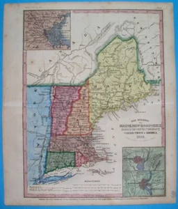
1850 ORIGINAL MAP UNITED STATES NEW YORK MASSACHUSETTS CONNECTICUT VERMONT MAINE

US $57.49
ApproximatelyPHP 3,198.86
or Best Offer
Condition:
“SOME STAINS, SOME SCATTERED SPOTTING AND FOXING //// I INVITE YOU TO MY SHOP”
Postage:
US $16.00 (approx PHP 890.27) Economy Shipping from outside US.
Located in: Zary, Poland
Delivery:
Estimated between Fri, 27 Sep and Wed, 9 Oct to 43230
Returns:
30 days return. Buyer pays for return shipping.
Coverage:
Read item description or contact seller for details. See all detailsSee all details on coverage
(Not eligible for eBay purchase protection programmes)
Shop with confidence
Seller assumes all responsibility for this listing.
eBay item number:196032931904
Item specifics
- Seller Notes
- “SOME STAINS, SOME SCATTERED SPOTTING AND FOXING //// I INVITE YOU TO MY SHOP”
- Date Range
- 1700-1799
- Type
- Political Map
- Printing Technique
- Copper Plate
- Format
- Atlas Map
- US State
- Connecticut, Maine, Massachusetts, New Hampshire, New York, Rhode Island, Vermont
- Year
- 1850 - dated map
- Canadian Province
- Quebec
- Cartographer/Publisher
- Meyer
- Original/Reproduction
- Antique Original
- City
- New York Boston New Haven Hartford Portland
- Country/Region
- United States of America
Item description from the seller

Seller feedback (1,102)
- o***m (373)- Feedback left by buyer.Past monthVerified purchaseGreat item - great communication. Received in reasonable time considering the constraints of Brexit. Thank you!
- 4***3 (117)- Feedback left by buyer.Past monthVerified purchasePerfect
- n***n (741)- Feedback left by buyer.Past monthVerified purchaseTutto OK. Ottimo venditore