Picture 1 of 3


Gallery
Picture 1 of 3


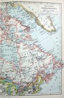
British North America - Original 1900 German Language Map by Meyers
US $17.00
ApproximatelyPHP 947.94
Condition:
“Some age toning, a bit of edge wear and one center fold, otherwise this rare map is in good ”... Read moreabout condition
Oops! Looks like we're having trouble connecting to our server.
Refresh your browser window to try again.
Shipping:
Free USPS Ground Advantage®.
Located in: Sayville, New York, United States
Delivery:
Estimated between Wed, 4 Jun and Mon, 9 Jun to 94104
Returns:
30 days return. Seller pays for return shipping.
Coverage:
Read item description or contact seller for details. See all detailsSee all details on coverage
(Not eligible for eBay purchase protection programmes)
Seller assumes all responsibility for this listing.
eBay item number:135701453479
Item specifics
- Seller Notes
- Date Range
- 1900-1909
- Type
- Map
- Format
- Atlas Map
- Printing Technique
- Lithography
- Year
- 1900
- Canadian Province
- Alberta, British Columbia, Manitoba, New Brunswick, Newfoundland & Labrador, Northwest Territories, Nova Scotia, Nunavut, Ontario, Prince Edward Island, Quebec, Saskatchewan, Yukon
- Original/Reproduction
- Original
- Country/Region
- Canada
- Maker
- Meyers
Item description from the seller

Popular categories from this store
Seller feedback (6,269)
- w***1 (1628)- Feedback left by buyer.Past monthVerified purchaseGreat seller
- a***a (956)- Feedback left by buyer.Past monthVerified purchaseMap as described. Fast,well-packaged shipping.
- a***r (642)- Feedback left by buyer.Past monthVerified purchaseJust as described. Well packaged.