Vintage Original Antique North America County Maps
620 Results
Vtg 1984-1985 Aerial Photo Map Book California San Diego County Rare Atlas
PHP 11,567.47PHP 4,296.95 shippingVintage 1949 LARGE MARYLAND MAP - HOWARD COUNTY Topography & Election Districts
PHP 7,461.39PHP 2,138.35 shippingVintage 1948 (36" x 23") MARYLAND MAP - HARFORD COUNTY Topo & Election Districts
PHP 7,461.39PHP 2,138.35 shippingRare 1940 Western Montana National Forest Map John B Lacasse & Sunday Missoulian
PHP 10,700.45PHP 2,561.17 shippingNew ListingVINTAGE BINGHAMTON NY CITY BROOME COUNTY NEW YORK STREET / HIGHWAY MAP
PHP 1,732.32PHP 1,865.93 shippingNew ListingOld 1915 Plat Map ~ WELLINGTON, WILTON, Twp., MONROE Co., WISCONSIN (LG14x17)
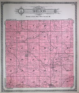
PHP 1,966.570 bidsPHP 1,093.18 shippingEnding May 21 at 6:59AM PHT4d 19hNew ListingOld 1915 Plat Map ~ SHELDON, OIL CITY, Twp., MONROE Co., WISCONSIN (LG14x17)
PHP 1,966.570 bidsPHP 1,093.18 shippingEnding May 21 at 4:34AM PHT4d 17hNew ListingOld 1915 Plat Map ~ OAKDALE, Twp., MONROE Co., WISCONSIN (LG14x17) Free S&H
PHP 1,966.570 bidsPHP 1,093.18 shippingEnding May 21 at 5:15AM PHT4d 18hNew ListingOld 1915 Plat Map ~ WILTON, Twp., MONROE Co., WISCONSIN (LG14x17) Free S&H
PHP 1,966.570 bidsPHP 1,093.18 shippingEnding May 21 at 6:13AM PHT4d 19hNew ListingOld 1915 Plat Map ~ WELLS, Twp., MONROE Co., WISCONSIN (LG14x17) Free S&H
PHP 1,966.570 bidsPHP 1,093.18 shippingEnding May 21 at 3:48AM PHT4d 16hNew ListingOld 1915 Plat Map ~ SCOTT, NORWAY RIDGE, Twp., MONROE Co., WISCONSIN (LG14x17)
PHP 1,966.570 bidsPHP 1,093.18 shippingEnding May 21 at 4:16AM PHT4d 17hNew ListingOld 1915 Plat Map ~ TOMAH, Twp., MONROE Co., WISCONSIN (LG14x17) Free S&H
PHP 1,966.570 bidsPHP 1,093.18 shippingEnding May 21 at 4:10AM PHT4d 17hNew ListingOld 1915 Plat Map ~ NORWALK, KENDALL, WARRENS, MONROE Co., WISCONSIN (XLG17x29)
PHP 1,966.570 bidsPHP 2,123.32 shippingEnding May 21 at 4:33AM PHT4d 17hAtlas of Divide County North Dakota Vintage 1991 Western Mapping Book NODAK
PHP 4,395.28Was: PHP 5,494.24PHP 2,805.83 shippingVtg Ravalli County Montana Road Index Map Collection FIRST EDITION Large 24"x18"
PHP 1,156.23PHP 4,894.44 shippingLand Use & Cover Maui County Hawaii Department Of Planning Development 1976 1978
PHP 2,302.62PHP 2,070.68 shippingNew ListingOld 1915 Plat Map ~ SOUTH PART of SPARTA Twp., MONROE Co., WISCONSIN (XLG17x29)
PHP 1,966.570 bidsPHP 2,123.32 shippingEnding May 21 at 4:30AM PHT4d 17hNew ListingOld 1915 Plat Map ~ TOMAH & LA GRANGE Twps., MONROE Co., WISCONSIN (XLG17x29)
PHP 1,966.570 bidsPHP 2,123.32 shippingEnding May 21 at 4:39AM PHT4d 17h1904 Plat Map ~ HUDSON Twp., DOUGLAS Co., MINNESOTA - LOVERS LAKE ~ Free S&H
PHP 2,657.76Was: PHP 2,827.23PHP 1,093.18 shippingCameron-Elk PA Counties 1958 Waters-Highway Map 1966 Deer&Bear Harvest Report
PHP 1,156.80PHP 1,822.55 shipping1929 Plat Map ~ UTICA, LA SALLE, Co., ILLINOIS / EDEN, VERMILLION on Reverse
PHP 2,498.12Was: PHP 2,657.76PHP 1,093.18 shippingNew Listing1944 Roanoke County VA Highway Roads Map Vintage Foldout
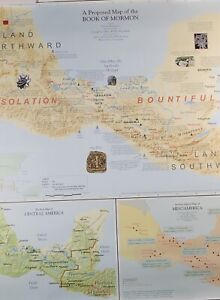
PHP 1,041.12PHP 1,900.05 shippingBOOK OF MORMON "A Proposed Map" 1998 Travel Poster 26" X 28" MINT CONDITION
PHP 5,726.18PHP 5,156.46 shippingVINTAGE ASBURY PARK, NEW JERSEY STREET MAP 18”x22” Wall Map MONMOUTH COUNTY, NJ
PHP 2,889.12PHP 1,900.05 shipping1960-70 Historic Sites Map of Sonoma Valley 17.5x22.25 in.
PHP 633.35PHP 5,051.77 shippingTexas Map Wilbarger County Vernon Oaklaunion Pease River Oil Fields Highways TX
PHP 577.82Was: PHP 722.42PHP 1,156.23 shipping✨Vintage 1975 Bi-Centennial Historical Map Of Rutherford County NC- 20”x14”✨
PHP 1,445.43PHP 7,346.29 shippingMap Of Rayburn Country Jasper County Texas American Lakes And Land Houston 1974
PHP 694.08PHP 1,805.19 shippingNEWFOUNDLAND NOVA SCOTIA GREAT LAKES REGION CANADA 14x18 Print MAP Labrador
PHP 9,543.64PHP 2,114.06 shippingParis Kentucky County Seat Of Bourbon Fold-Out Map 5th Edition 1954
PHP 867.60PHP 1,801.72 shipping1977 Council Bluffs Iowa City and Pottawattamie County Map
PHP 578.40PHP 2,693.62 shippingLarge Vintage VAN BUREN County Tennessee Highway Map, RR, Bridges & Much More
PHP 694.08Was: PHP 867.60PHP 1,371.39 shippingOld (15x17) 1929 County / Plat Map ~ TAZEWELL COUNTY, ILLINOIS ~ Free S&H
PHP 2,657.76Was: PHP 2,827.23PHP 1,093.18 shippingOld Original 1881 Plat Map ~ THE GREEN - WIER ST., TAUNTON, MA - HIGH ST.
PHP 2,498.12Was: PHP 2,657.76PHP 1,093.18 shippingMetsker's Atlas of Stevens County Washington Maps Property Landmarks Roads Folio
PHP 8,647.12PHP 5,135.64 shippingANTIQUE 1898 RAND McNALLY 10 1/2” X 15” MAP OF THE STATE OF OHIO
PHP 519.98PHP 315.23 shippingVINTAGE 1930'S ITHACA N.Y. MAP
PHP 1,034.18PHP 231.36 shippingANTIQUE 1898 RAND McNALLY 10 1/2” X 15” MAP WEST OKLAHOMA & INDIAN TERRITORY
PHP 519.98PHP 315.23 shippingVintage Battle Creek Calhoun County Michigan..AAA Road Map
PHP 489.91PHP 1,831.80 shipping55 Vintage 1960s Michigan County Wall Maps DNR 22 Different Counties
PHP 2,747.41Was: PHP 2,892.01PHP 3,465.79 shippingVintage 1986 WILKIN County, Minnesota Rural Resident Directory Plat Book
PHP 462.14PHP 1,926.66 shippingKentucky Soil Survey of Scott County with b&w and color maps 1971 book vintage
PHP 2,197.93PHP 2,741.05 shippingOld Original 1881 Plat Map ~ MAYFLOWER HILL CEM., TAUNTON, MA - BROADWAY
PHP 2,657.76Was: PHP 2,827.23PHP 1,093.18 shipping1974 Zoning Map Of Ketchum Blaine County OldPaperMaps
PHP 1,734.63PHP 1,579.62 shippingVINTAGE LAND ATLAS & PLAT BOOK 2021 COUNTY CARLTON MINNESOTA ROCKFORD MAP
PHP 577.82PHP 2,025.57 shipping1929 Plat Map ~ MANLIUS, LA SALLE, Co, ILLINOIS / DIMMICK on Reverse
PHP 2,657.76Was: PHP 2,827.23PHP 1,093.18 shipping1929 Plat Map OTTAWA & SOUTH OTTAWA, LA SALLE, Co, ILLINOIS / FALL RIVER Reverse
PHP 2,657.76Was: PHP 2,827.23PHP 1,093.18 shipping1929 Plat Map ~ CITY of PERU, LA SALLE, Co., IL / LOSTANT, RUTLAND on Reverse
PHP 2,498.12Was: PHP 2,657.76PHP 1,093.18 shippingVintage “A GRAPHIC HISTORY OF DELAWARE COUNTY” Map Lay Out Of 4 Centuries R
PHP 2,602.81PHP 1,605.07 shipping1929 Plat Map ~ MENDOTA, LA SALLE, Co, ILLINOIS / MISSION on Reverse
PHP 2,657.76Was: PHP 2,827.23PHP 1,093.18 shipping1929 Plat Map ~ EARL, LA SALLE, Co, ILLINOIS / MERIDEN on Reverse
PHP 2,657.76Was: PHP 2,827.23PHP 1,093.18 shippingOld Original 1881 Plat Map ~ CITY of TAUNTON, MASSACHUSETTS (XL28x17)
PHP 2,657.76Was: PHP 2,827.23PHP 1,093.18 shippingWEST VIRGINIA Soil Survey of GREENBRIER County with b&w and color maps vintage
PHP 2,197.93PHP 2,741.05 shippingLand Use & Cover 1974 Crater Lake Oregon, Diamond Lake 1974Us Geological Survey
PHP 691.19PHP 1,895.42 shippingTexas Map - Hardeman County - Quanah Chillicothe Acme Goodlett Medicine Mound
PHP 577.82Was: PHP 722.42PHP 1,156.23 shippingOld Original 1881 Plat Map ~ UNITARIAN CHURCH, DEAN ST., TAUNTON, MA - HIGH ST.
PHP 2,498.12Was: PHP 2,657.76PHP 1,093.18 shipping1929 Plat Map STREATOR Twp., LA SALLE, Co., ILLINOIS / TONICA Twp. on Reverse
PHP 2,498.12Was: PHP 2,657.76PHP 1,093.18 shipping1955 Tazewell County, Illinois Plat Book
PHP 1,040.55PHP 1,902.94 shippingLarge Vintage Perry County Tennessee Highway Map, RR, Bridges & Much More
PHP 694.08Was: PHP 867.60PHP 1,371.39 shippingLarge Vintage Pickett County Tennessee Highway Map, RR, Bridges & Much More
PHP 694.08Was: PHP 867.60PHP 1,371.39 shipping