United Kingdom Antique Europe Folding Maps
169 Results
🌟Antique Framed Robert Morden - Oxfordshire map circa 1722 "Frame 54cm X 62cm🌟
PHP 5,823.53Was: PHP 7,279.60PHP 4,542.20 shipping⚡An antique map of Huntingdonshire by J. & C. Walker. Published by Longman 1836⚡
PHP 4,653.59Was: PHP 5,816.98PHP 3,656.91 shippingNew Listing1964 THE COUNTY BOROUGH OF STOCKPORT ENGLAND MAP & HANDBOOK - J
PHP 1,148.78PHP 1,022.93 shipping1908 UERL Johnson & Riddle Antique London Underground Map Rare 2nd Map Published
PHP 30,027.01PHP 861.44 shippingNew Listing1946 Kew Royal Botanical Gardens O.S.Key Pan Map & Train & Trolleybus route Map
PHP 364.020 bidsPHP 524.18 shippingEnding May 28 at 5:05AM PHT9d 18hJAMES WYLD WYLD’s ANTIQUE CLOTH MAP OF STAFFORD 1891 19th CENTURY SCARCE
PHP 3,388.26PHP 1,816.44 shippingISLE OF WIGHT BY WILLIAM MUDGE c1810 GENUINE 1st EDITION ORDNANCE SURVEY MAP
PHP 10,920.49PHP 582.43 shipping1920 Ordnance Survey Ipswich Vintage Map CLOTH PANELS
PHP 945.71PHP 364.02 shippingAntique Map Britannia Antiqua Ancient Britain C1870's Map Of The World
PHP 1,018.52PHP 360.38 shippingNew ListingBacon's motoring and cycling road map 100 miles round Manchester
PHP 873.64PHP 2,641.30 shippingKENT MAIDSTONE BY WILLIAM MUDGE c1819 GENUINE 1st EDITION ORDNANCE SURVEY MAP
PHP 10,556.48PHP 582.43 shippingHAMPSHIRE SOUTH BY WILLIAM MUDGE c1810 GENUINE 1st EDITION ORDNANCE SURVEY MAP
PHP 14,196.64PHP 582.43 shipping1816-19 MAPS Environs of London by Col MUDGE at the Tower 4 Sheets in a Slipcase
PHP 69,163.12PHP 2,329.71 shipping* Rare * Copperplate Engraved Map of Essex By John Seller Hand Coloured 1695
PHP 6,552.30PHP 1,161.21 shippingMap Of Bagshot to Southampton By John Senex Coloured By Hand 1767
PHP 5,460.25PHP 1,161.21 shippingVintage Street Plan & Map - Salisbury UK 1940’s
PHP 693.64Was: PHP 990.75PHP 1,793.58 shippingHAMPSHIRE NORTH BY WILLIAM MUDGE c1817 GENUINE 1st EDITION ORDNANCE SURVEY MAP
PHP 8,736.39PHP 582.43 shippingEighteenth Century Hand-Col. Map of London & Environs, 1787 - PRICE REDUCED
PHP 4,022.76PHP 1,436.70 shippingMap of "The British Isles & Irish Free State” National Geographic 1937
PHP 2,528.59PHP 1,838.97 shipping1938 Linen Backed STREET MAP of LONDON by Alexander Gross BOUND IN CLOTH
PHP 4,004.18PHP 1,656.27 shippingKENT ROMNEY MARSH BY WILLIAM MUDGE c1816 GENUINE 1st EDITION ORDNANCE SURVEY MAP
PHP 4,004.18PHP 582.43 shippingVintage London 1652 Tissue Paper Map 33cm X 33cm Stained Crinkled Torn Folded
PHP 724.39PHP 2,750.51 shippingBartholomew's, 1949 Pocket Plan Of Glasgow & Suburbs. City Plan. Cloth Map.
PHP 691.63PHP 2,891.75 shippingAntique Map Britannia Antiqua Adcurante Johanne Horsley C1877 UK Engraving
PHP 727.30PHP 360.38 shippingCassell’s Children’s Book of Knowledge Wonder Map of the World. c1930s
PHP 14,196.64PHP 3,655.45 shippingOrdnance survey map Gloucester & Malvern, 1953 reprint with new major roads 1962
PHP 272.970 bidsEnding May 26 at 1:15AM PHT7d 14hPHP 1,417.73 shippingKENT CANTERBURY BY WILLIAM MUDGE c1819 GENUINE 1st EDITION ORDNANCE SURVEY MAP
PHP 12,740.58PHP 582.43 shipping1964-65 Britain & Northern Ireland Map from BRITISH TRAVEL -NICE CONDITION!-
PHP 85.631 bidPHP 1,808.52 shippingEnding May 19 at 1:17AM PHT14h 33mRare Antique Map William Faden The Ottomans Or Turkey In Europe 1820 With Case
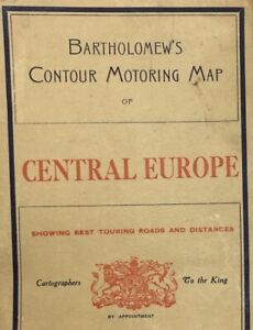
PHP 27,301.23PHP 3,907.35 shippingPost WWI-The Great War Bartholomews Contour Motoring Map Central Europe On Cloth
PHP 10,890.18PHP 3,718.75 shippingTHE PICTOGRAPHIC MAP OF BOURNEMOUTH Beautiful Vintage Map
PHP 2,184.10PHP 2,852.43 shippingVintage Naval Map of Western Approaches to Orkney and Shetland Islands, UK
PHP 3,390.61Free postage1620 MERCATOR MAP OF YORKSHIRE LINCS STAFFS LEICS & NORFOLK INSCRIBED in DUTCH *
PHP 7,279.60PHP 1,601.67 shippingVintage Cloth Map 1923 - Edward Stanford Ltd 72SW - Billericay Burstead Ramsden
PHP 728.03PHP 2,872.09 shipping1641 LARGE MAP Copper Hand Col ROMAN British Isles Britannica Insulae Sanson
PHP 18,200.82PHP 1,674.48 shipping1933 Pictorial Plan of London by Geographia In Original Guide
PHP 2,912.13PHP 509.62 shipping1610 COLOUR MAP of the EAST RIDING OF YORKSHIRE BY SAXTON & HOLE EBORACENSIS *
PHP 11,647.80PHP 1,601.67 shippingAntique Map "Stanford’s Map of the County of London(Sheet 4)" E. Stanford, 1901
PHP 22,205.00PHP 1,310.46 shippingEdwardian Philips' Tape Map of London, George & Son Ltd c1910 Green Outer boards
PHP 35,600.81PHP 5,143.55 shipping1906 Ordnance Survey Folding Map Oxford England Velum Cloth 27" x 25 7/8"
PHP 1,063.16PHP 1,880.35 shippingOrdinance Survey Contoured Road Map of Birmingham no 72, c1930
PHP 728.030 bidsEnding May 21 at 11:13PM PHT3d 12hPHP 873.64 shipping1646 COLOUR MAP OF EAST RIDING YORKSHIRE JANSSON EBORACENSIS PARS ORIENTALIS *
PHP 5,823.53PHP 1,601.67 shipping19th Century Map of Northamptonshire Edward Stanford HAND COLOURED Ordnance
PHP 1,456.07PHP 1,092.05 shipping1882 Ordnance Survey Sheet 302 HORSHAM Brighton Tunbridge Wells Haslemere 1 Inch
PHP 3,640.16PHP 2,329.71 shipping1810 MAP Ordnance Survey of the Isle of Wight And part of Hampshire LARGE FORMAT
PHP 12,012.54PHP 1,674.48 shippingBartholomews Half Inch Map 35 Teesdale 1968 Edition 1:126,720
PHP 218.41PHP 371.30 shippingVintage 1978 East London MAP 177 Ordnance Survey One-Inch Map Topography History
PHP 509.62PHP 2,360.28 shippingc1820 MAP Cornwall From a recent Survey With the Railways SCARCE ORIGINAL Linen
PHP 14,560.66PHP 1,674.48 shippingSURREY & SUSSEX. W H SMITH ORDNANCE SURVEY MAP c1900. COLOUR. LINEN. 4m to 1 ins
PHP 655.23PHP 655.23 shipping1891 Map of London and environs - F.S. Weller / London, Cassell & Company
PHP 945.71PHP 2,857.53 shippingOrdnance Survey Cheshire Cloth Map Sheet SJ 47 Property of BMNH 1952
PHP 1,092.05PHP 2,616.55 shippingVintage Cloth Map 1923 - Ordnance Survey 62SW - Blackmore Stondon Massey Hatch +
PHP 728.03PHP 2,695.91 shippingVintage 1961 Newquay Padstow OS Ordnance Survey 1 inch Seventh Series Map 185
PHP 582.43PHP 422.26 shipping1922 Map Lizard to Bishop Rock Cornwall Scilly Isles Hand Coloured Map Scarce
PHP 8,008.36PHP 2,329.71 shipping1937 Map of "The British Isles" - National Geographic Magazine Ireland England
PHP 1,091.89PHP 1,907.36 shippingc1830 MAP Somersetshire Divided into Hundreds &c and the Parliamentary Divisions
PHP 8,372.38PHP 1,674.48 shipping1960 Ordnance Survey Seventh Series One Inch Map Exeter Sheet 176
PHP 360.38PHP 291.21 shippingVintage Bacon's New Cycling Road Map Of Reading And District
PHP 1,092.05PHP 2,401.78 shippingAntique UK Map England & Wales Bristol and Bath Linen Backed Bartholomew's 1930s
PHP 1,499.34Was: PHP 1,723.46PHP 1,799.90 shippingMagyarország politikai térképe On Cloth 1920-30 Hungary Map Gergely 16 X 11-1/2
PHP 3,879.09Was: PHP 4,310.10PHP 2,141.26 shipping