England 1700-1799 Date Range Antique Europe Atlas Maps
554 Results
1782 English Channel & West Coasts of France, Spain & Portugal Antique Map
PHP 2,600.01PHP 817.15 shipping1747 Roman Britain Original Antique Map by Richard Seale
PHP 3,714.30PHP 817.15 shippingAntique Map-BRITANNIAE ROMANAE-ENGLAND DURING THE ROMAN EMPIRE-Weigel-1720
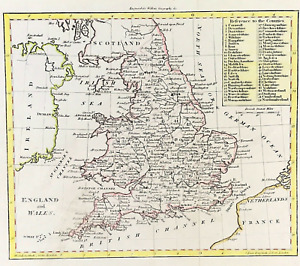
PHP 9,940.77Free postageAntique Map-South England and counties-London-Sussex-Kent-Wales-Sanson-ca. 1720
PHP 14,632.57Free postageNew Listing1780 ORIGINAL MAP GREAT BRITAIN ENGLAND IRELAND SCOTLAND WALES Dublin London
PHP 3,225.030 bidsEnding Jun 28 at 5:59AM PHT9d 21hPHP 938.36 shippingMITCHAM, SUTTON, BANSTEAD DOWNS, REIGATE, original antique road map, CARY, 1790
PHP 2,600.01PHP 705.72 shippingKENT, CANTERBURY, DOVER, BRITANNIA DEPICTA original antique map, Bowen 1720
PHP 1,374.29PHP 705.72 shippingMELTON MOWBRAY, ROTHERHAM, BARNSLEY, original antique road map, Bowen, 1720
PHP 1,374.29PHP 705.72 shippingHasted, Kent. The Isle of Thanet, Hundred of Ringslow- genuine antique map 1793.
PHP 5,571.45PHP 3,651.16 shippingST ALBANS, LUTON, BEDFORD, KETTERING, original antique road map, Bowen, 1720
PHP 1,374.29PHP 705.72 shippingSURREY, CROYDON, SUSSEX, BRIGHTON, SHOREHAM, original antique map, Bowen, 1720
PHP 1,374.29PHP 705.72 shippingTEMPSFORD, ST NEOTS, STILTON, PETERBOROUGH original antique road map, Bowen 1720
PHP 1,374.29PHP 705.72 shipping1795 The Huddersfield Narrow Canal To Ashton Under Lyne Original Antique Map
PHP 1,484.98PHP 594.29 shipping1794 Huntingdonshire Original Antique Map by Thomas Conder
PHP 1,485.72PHP 594.29 shipping1794 Worcestshire Original Antique Map by Thomas Conder
PHP 1,485.72PHP 594.29 shipping1769 D Anville Large Antique Map Western Roman Empire - Europe, Italy to England
PHP 3,460.21PHP 585.89 shippingWILTSHIRE, SOMERSET, CHIPPENHAM, BATH, original antique road map, Bowen, 1720
PHP 1,374.29PHP 705.72 shippingCAMBRIDGESHIRE COUNTY MAP, BRITANNIA DEPICTA, original antique map, Bowen, 1720
PHP 2,228.58PHP 705.72 shippingDERBYSHIRE COUNTY MAP, BRITANNIA DEPICTA original antique map, Bowen, 1720
PHP 2,228.58PHP 705.72 shippingBuckinghamshire. Original 18th Century copperplate map by Thomas Osborne, 1748
PHP 1,485.72PHP 3,281.21 shipping1681 (1715) Antique Map; Dorset by Richard Blome
PHP 3,342.13PHP 386.29 shippingSTAFFORDSHIRE COUNTY MAP, BRITANNIA DEPICTA original antique map, Bowen, 1720
PHP 2,228.58PHP 705.72 shippingSHROPSHIRE COUNTY MAP, BRITANNIA DEPICTA, original antique map, Bowen, 1720
PHP 2,228.58PHP 705.72 shippingCHANNEL ISLANDS, ISLE OF WIGHT, SCILLY ISLES, original antique map, Bowen, 1720
PHP 2,228.58PHP 705.72 shippingCAMBRIDGE, ELY, DOWNHAM, KING'S LYNN, original antique road map, Bowen, 1720
PHP 1,374.29PHP 705.72 shippingRUTLANDSHIRE, RUTLAND, BRITANNIA DEPICTA, original antique map, Bowen, 1720
PHP 2,080.01PHP 705.72 shippingNEWCASTLE UNDER LYME, WARRINGTON, WIGAN, original antique road map, Bowen, 1720
PHP 1,374.29PHP 705.72 shippingBEDFORDSHIRE COUNTY MAP, BRITANNIA DEPICTA, original antique map, Bowen, 1720
PHP 2,080.01PHP 705.72 shippingAntique Map-GREAT BRITAIN-ENGLAND-WALES-NORTHERN PART-Andree-1904
PHP 2,903.06PHP 876.78 shipping1744 Eugène Henri Fricx, Environs de Calais, Boulogne, France 75.5 cm, map
PHP 12,630.34Was: PHP 14,859.54PHP 480.32 shipping1695 COUNTY of BARKSHIRE ( Berkshire ) Original English Antique Map MORDEN
PHP 4,828.59PHP 1,448.58 shippingAntique Print-CUSTOM HOUSE-SOUTHERN PART OF ENGLAND-Thomson-1817
PHP 19,617.62Free postage1681 (1715) Antique Map; Sussex by Richard Blome / Hollar
PHP 3,713.56PHP 386.29 shipping14 watchingLANCASTER, KENDAL, PENRITH, CARLISLE, original antique road map, Bowen, 1720
PHP 1,374.29PHP 705.72 shippingMARKET DEEPING, SLEAFORD, LINCOLN, BARTON, original antique road map, Bowen 1720
PHP 1,374.29PHP 705.72 shippingBARNSLEY, HALIFAX, SKIPTON, RICHMOND, original antique road map, Bowen, 1720
PHP 1,374.29PHP 705.72 shippingHATFIELD, BALDOCK, ST NEOTS, OAKHAM, original antique road map, Bowen, 1720
PHP 1,374.29PHP 705.72 shippingSTILTON, PETERBOROUGH, CROWLAND, SPALDING original antique road map, Bowen, 1720
PHP 1,374.29PHP 705.72 shipping1785 Johann Probst Map Great Britain England Scotland Wales Ireland London UK
PHP 9,336.70Was: PHP 11,670.87PHP 1,172.37 shipping1798 Johann Probst Map Europe France England Germany Spain Holland Italy Sweden
PHP 9,336.70Was: PHP 11,670.87PHP 1,172.37 shippingNORTHAMPTON, LEICESTER, KEGWORTH, DERBY, original antique road map, Bowen, 1720
PHP 1,374.29PHP 705.72 shippingTUNBRIDGE, TUNBRIDGE WELLS, LONDON, original antique road map, CARY, 1790
PHP 2,971.44PHP 705.72 shippingLONDON, CHELMSFORD, HARWICH, BRITANNIA DEPICTA original antique map, Bowen 1720
PHP 1,374.29PHP 705.72 shippingSURREY COUNTY MAP, BRITANNIA DEPICTA original antique map, Bowen, 1720
PHP 2,228.58PHP 705.72 shippingMERIONETHSHIRE, WALES, BRITANNIA DEPICTA, original antique map, Bowen, 1720
PHP 2,080.01PHP 705.72 shipping1720 ANTIQUE COPPER ENGRAVED WARD MAP COW CROSS LONDON - STRYPE / STOW
PHP 2,224.86PHP 3,057.61 shippingANGLESEY, MONA, WALES, BRITANNIA DEPICTA, original antique map, Bowen, 1720
PHP 2,080.01PHP 705.72 shippingYORKSHIRE, TADCASTER, YORK, NORTHALLERTON original antique road map, Bowen, 1720
PHP 1,374.29PHP 705.72 shippingHODDESDON, SPITAL BROOK, HERTFORD, WARE, original antique road map CARY, 1790
PHP 2,600.01PHP 705.72 shippingSURREY, LONDON, TOOTING, REIGATE, Pl 103 antique road map, Jefferys 1775
PHP 2,451.44PHP 705.72 shippingROYSTON, HUNTINGDON, STILTON, STAMFORD, original antique road map, Bowen, 1720
PHP 1,374.29PHP 705.72 shippingEngland map & Wales c1801 engraved for Walkers Geography hand colour
PHP 2,302.86PHP 661.15 shippingOriginal antique road map LONDON, HOUNSLOW, HENLEY, DORCHESTER, Bowen c.1724
PHP 1,374.29PHP 705.72 shippingEAST GRINSTEAD, NEWINGTON BUTTS, BALHAM, original antique road map, CARY, 1790
PHP 2,600.01PHP 705.72 shippingSAWBRIDGEWORTH, BISHOPS STORTFORD, LONDON, original antique road map CARY, 1790
PHP 2,600.01PHP 705.72 shipping1839 ORIGINAL MAP POLAND LITHUANIA UKRAINE ITALY SPAIN FRANCE ROMANIA CROATIA
PHP 3,811.510 bidsEnding Jun 26 at 6:41AM PHT7d 21hPHP 938.36 shippingTHOMAS KITCHIN -ANTIQUE HAND COLOUR MAP-A NEW MAP OF LINCOLNSHIRE-1764
PHP 1,634.29PHP 1,114.29 shipping1681 (1700) Antique Map; Monmouth by Richard Blome
PHP 2,970.70PHP 386.29 shipping1794 Berkshire Original Antique Map by Thomas Bowen
PHP 1,485.72PHP 594.29 shipping1793 West Yorkshire Original Antique Map by John Cary Hand Coloured in Outline
PHP 1,856.41PHP 594.29 shipping