Antique North American Maps & Atlases 1400-1499 Date Range
All
Auction
Buy It Now
9 Results
Nautical Chart No. 1499 United States - Alaska, Cross Sound to Kodiak Island
PHP 2,441.04PHP 2,639.20 shippingChristopher Columbus Map Of 1492 America 24”x 29.25”
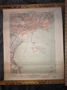
PHP 112,462.70PHP 3,442.74 shippingOriginal 1950 U. S. Dept. of Interior Geological Map, Boston North, Medford
PHP 2,866.08PHP 1,988.18 shippingC. 1868 Hand-Colored Atlas Map Of Lurgen Twp., Franklin Co., PA 15.5 x 14.25”
PHP 2,868.95PHP 2,441.47 shippingYield of Gold & Silver since 1492. Mexico Bolivia Peru US Australia 1885 map
PHP 1,076.93PHP 933.34 shippingOriginal 1943 U. S. Dept. of Interior Geological Lynn, Swampscott, Nahant MA
PHP 2,866.08PHP 1,988.18 shippingOriginal 1943 United States Dept. of Interior Geological Survey Map Exeter NH !
PHP 2,866.08PHP 1,988.18 shippingOriginal 1949 U S Dept. of Interior Geological Survey Map Gloucester Quadrangle
PHP 2,866.08PHP 1,996.79 shippingOriginal 1942 U. S. Dept. of Interior Geological Survey Map Newburyport MA, NH.
PHP 2,866.08PHP 1,988.18 shipping