Antique European Maps & Atlases England 1700-1799 Date Range
1,438 Results
Ancient Britain Roman England Wales 1797 Neele engraved historical map
PHP 7,751.05PHP 2,144.46 shippingYarmouth England Norfolk City Walls c. 1760 Bellin hand color engraved fine map
PHP 7,751.05PHP 2,144.46 shipping1794 Country Around Manchester Large Folding Map by Stockdale 84 cm x 81 cm
PHP 12,567.10PHP 574.50 shippingEngland & Wales United Kingdom 1780 engraved hand colored map
PHP 5,626.69PHP 2,081.87 shippingROCHESTER ENGLAND 1738 NATHANIEL BUCK LARGE UNUSUAL ANTIQUE COPPER ENGRAVED VIEW
ANTIQUE COPPER ENGRAVED VIEW OF ROCHESTER ENGLAND 1738PHP 1,148.301 bidPHP 1,435.38 shippingEnding Tuesday at 1:09PM PHT14h 7mAntique Sea Chart ENGLISH CHANNEL England & France G.Collins Nautical Map 1756
PHP 39,137.55PHP 1,328.52 shippingLONDON, CHELMSFORD, HARWICH, BRITANNIA DEPICTA original antique map, Bowen 1720
PHP 1,328.52PHP 682.21 shippingMONMOUTH, CARDIFF, ABERAVON, BRITANNIA DEPICTA, original antique map, Bowen 1720
PHP 1,328.52PHP 682.21 shipping1795 Chester City Plan Original Antique Map by John Stockdale
PHP 3,589.88PHP 574.50 shippingNORTHAMPTONSHIRE COUNTY MAP, BRITANNIA DEPICTA original antique map, Bowen, 1720
PHP 2,154.36PHP 682.21 shippingAntique map of Gloucestershire by Robert Morden 1715
PHP 3,231.54PHP 502.68 shippingKENT, CANTERBURY, DOVER, BRITANNIA DEPICTA original antique map, Bowen 1720
PHP 1,328.52PHP 682.21 shippingLONDON TO CHICHESTER WINCHESTER BY JOHN OGILBY REDUCED BY THOMAS GARDNER c1719
PHP 4,308.72PHP 574.50 shippingPortsmouth England United Kingdom city plan St. Helen Spit Head 1760 Bellin map
PHP 11,195.96PHP 2,246.08 shipping1764 Norfolk England antique hand colored map Kitchin
PHP 1,722.46PHP 3,591.32 shippingEngland & Wales British Isles London Cardiff York c 1750-75 Jeffrys engraved map
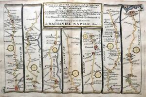
PHP 8,612.28PHP 2,170.29 shippingROYSTON, HUNTINGDON, STILTON, STAMFORD, original antique road map, Bowen, 1720
PHP 1,328.52PHP 682.21 shippingTHOMAS KITCHIN -ANTIQUE HAND COLOUR MAP-A NEW MAP OF LINCOLNSHIRE-1764
PHP 1,579.86PHP 1,077.18 shipping1840 ORIGINAL MAP GREAT BRITAIN IRELAND ENGLAND SCOTLAND WALES Dublin London
PHP 3,157.26PHP 918.64 shippingRUTLANDSHIRE RUTLAND BY ROBERT MORDEN c1727 GENUINE ANTIQUE ENGRAVED MAP
PHP 3,230.82PHP 574.50 shippingLEICESTERSHIRE BY BADESLADE & TOMS c1742 ORIGINAL HAND COLOUR GENUINE ANTIQUE
PHP 2,871.76PHP 574.50 shippingmap of Norfolk by Bowen original copper engraved large antique map c1763
PHP 22,979.85PHP 567.31 shippingDEVON CORNWALL LAUNCESTON BARNSTAPLE BY EMANUEL BOWEN GENUINE ANTIQUE c1720
PHP 2,153.64PHP 574.50 shippingCAMBRIDGESHIRE CAMBRIDGE BY EMANUEL BOWEN c1720 GENUINE ANTIQUE ENGRAVED MAP
PHP 2,871.76PHP 574.50 shipping1681 (1715) Antique Map; Sussex by Richard Blome / Hollar
PHP 3,589.88PHP 373.42 shipping15 watchingCORNWALL DEVON ROAD MAP BY JOHN OGILBY REDUCED BY THOMAS GARDNER c1719
PHP 4,308.72PHP 574.50 shippingOXFORD TO SALISBURY & POOLE BY JOHN OGILBY REDUCED BY THOMAS GARDNER c1719
PHP 3,590.60PHP 574.50 shipping1795 West Yorkshire Original Antique Map by John Stockdale
PHP 1,794.58PHP 574.50 shippingNew ListingEngland & Wales London Cardiff York Manchester c. 1770-80 Conder hand color map
PHP 5,626.69PHP 2,081.87 shippingAntique 1771 Map, Derby Shire, England, Plan of Grand Canal Trent to Hersey
PHP 5,451.57PHP 1,677.67 shipping1760 London Map
PHP 7,176.90PHP 4,073.03 shipping1782 English Channel & West Coasts of France, Spain & Portugal Antique Map
PHP 2,513.42PHP 789.93 shippingMITCHAM, SUTTON, BANSTEAD DOWNS, REIGATE, original antique road map, CARY, 1790
PHP 2,513.42PHP 682.21 shippingDORKING, LEATHERHEAD, FETCHAM, EFFINGHAM, , original antique road map CARY, 1790
PHP 2,513.42PHP 682.21 shippingLONDON TO HOLYHEAD ROAD MAP BY JOHN OGILBY REDUCED BY THOMAS GARDNER c1719
PHP 3,590.60PHP 574.50 shippingWILTSHIRE DORSET ROAD MAP BY JOHN OGILBY REDUCED BY THOMAS GARDNER c1719
PHP 3,949.66PHP 574.50 shippingLONDON TO BERWICK STILTON BY JOHN OGILBY REDUCED BY THOMAS GARDNER c1719
PHP 3,590.60PHP 574.50 shipping1722 ROBERT MORDEN MAP OF NORFOLK - Norwich Yarmouth Blakeney Thetford Diss
PHP 5,744.240 bidsPHP 1,579.86 shippingEnding May 20 at 2:08AM PHT6d 3hEngland & Wales United Kingdom London 1772 Jefferys decorative hand color map
PHP 6,602.74PHP 2,110.58 shipping1795 The Huddersfield Narrow Canal To Ashton Under Lyne Original Antique Map
PHP 1,435.52PHP 574.50 shippingTUNBRIDGE, TUNBRIDGE WELLS, LONDON, original antique road map, CARY, 1790
PHP 2,872.48PHP 682.21 shippingESSEX CHELMSFORD BRENTWOOD SUFFOLK NORFOLK BY PATERSON c1785 GENUINE ANTIQUE MAP
PHP 1,076.46PHP 574.50 shippingGLOUCESTER CHELTENHAM MONMOUTH BRECON BY PATERSON c1785 GENUINE ANTIQUE MAP
PHP 1,435.52PHP 574.50 shipping1795 The Huddersfield Narrow Canal To Ashton Under Lyne Antique Map
PHP 1,794.58PHP 574.50 shippingFARNBOROUGH, SEVENOAKS, KNOLE PARK, original antique road map, CARY, 1790
PHP 2,513.42PHP 682.21 shippingEXETER TO DORCHESTER ROAD MAP BY JOHN OGILBY REDUCED BY THOMAS GARDNER c1719
PHP 3,949.66PHP 574.50 shippingLONDON TO BERWICK YORK ROAD MAP BY JOHN OGILBY REDUCED BY THOMAS GARDNER c1719
PHP 3,590.60PHP 574.50 shippingOXFORD TO CHICHESTER BY JOHN OGILBY REDUCED BY THOMAS GARDNER c1719
PHP 3,590.60PHP 574.50 shippingROCHESTER, CHATHAM, LEWISHAM, ELTHAM, SIDCUP original antique road map CARY 1790
PHP 2,513.42PHP 682.21 shippingSURREY, Thomas Kitchin, London Magazine, Original Antique County Map 1750
PHP 3,446.98PHP 682.21 shippingSUSSEX BRIGHTON CHICHESTER HASTINGS BY JOHN ROCQUE GENUINE ANTIQUE MAP c1769
PHP 3,589.88PHP 574.50 shippingYORK TO WHITBY & SCARBOROUGH BY JOHN OGILBY REDUCED BY THOMAS GARDNER c1719
PHP 3,949.66PHP 574.50 shippingGLOUCESTER TO COVENTRY BY JOHN OGILBY REDUCED BY THOMAS GARDNER c1719
PHP 4,667.78PHP 574.50 shippingHAMPSHIRE BY GEORGE BICKHAM c1754 BIRDS EYE VIEW PLUS 3 PAGES OF DESCRIPTION
PHP 19,748.31PHP 574.50 shippingRADNORSHIRE COUNTY MAP, BRITANNIA DEPICTA, original antique map, Bowen, 1720
PHP 1,436.24PHP 682.21 shipping1794 Worcestshire Original Antique Map by Thomas Conder
PHP 1,436.24PHP 574.50 shippingABINGDON, LECHLADE ON THAMES, GLOUCESTER, original antique road map, Bowen, 1720
PHP 1,328.52PHP 682.21 shippingLANCASHIRE MANCHESTER CAMBRIDGE ELY BY PATERSON c1785 GENUINE ANTIQUE MAP
PHP 1,076.46PHP 574.50 shippingBritish Isles England Wales Scotland Ireland 1761 Delisle Buache scarce map
PHP 7,176.90PHP 2,127.81 shippingLondon England Mansion House active street view c.1760 Vue d'optique print
PHP 12,918.41PHP 2,297.18 shipping